


Marine Ways - Nautical Charts
Marine Ways - Nautical Chartsの説明
Marine Ways Boating は、究極の海洋ナビゲーションおよび計画アプリケーションです。このアプリケーションでは、次のものにアクセスできます。
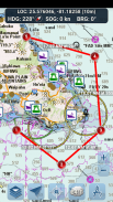
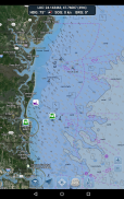
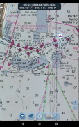
海図
- 米国海洋大気庁 (NOAA) が提供する米国海図
- Land Information New Zealand (LINZ) が提供するニュージーランドのチャート
グラフの種類:
- NOAA Electronic Navigational Charts (ENC) (NOAA の最新かつ最も強力な電子海図製品)。
- NOAA クラシック チャート (デイ、レッド、ダスク、ナイト、グレイ バージョンを含む)。
- LINZ チャート (現在、昼、夕暮れ、夜のバージョンでのみ利用可能)
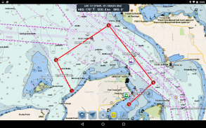
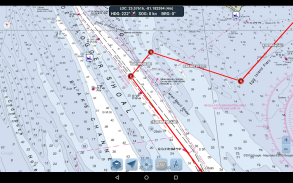
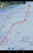
ルート計画ツール
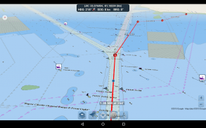
-ルート プロット。ウェイポイントをプロットするには、マップを 1 秒間タップ アンド ホールドします。ルートを形成するには、マップ上のさまざまなエリアをタップ アンド ホールドし続けます。ウェイポイントを追加、調整、または削除すると、各区間の距離と方位が便利に計算されて表示されます。
-トラベルモード。移動すると、現在の位置を自動的にマップの中心にします。トラベル モードを使用して、プロットされたルートをどれだけ正確にたどっているかをリアルタイムで確認してください。
-ルートレグのまとめ。始点と終点の座標、距離、方位など、プロットした各区間の詳細情報を含む便利なビュー。
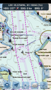
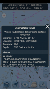
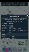
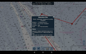
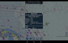
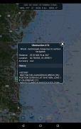
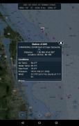
ブイレポートと障害情報
ブイと障害物のマーカーは、地図上の実際の位置に便利にプロットされます!マーカーをクリックするだけで、その情報を表示できます。
- ブイ レポート: 固定および漂流ブイの完全な現在の状態と波のレポートを取得します。
- 障害物: 岩や沈没船など、潜在的に危険な水没危険物に関する位置情報と履歴情報を取得します。
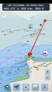
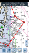
ナビゲーション ダッシュボード
ナビゲーション ダッシュボードには、次のようなさまざまなリアルタイム情報が表示されます。
- 現在地(緯度経度、精度範囲付き)
- 現在の進行方向 (小さな方向コンパスも含まれています!)
- 地上の現在の速度
- 現在のベアリング
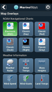
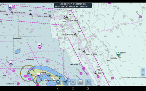
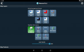
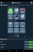
海洋地図オーバーレイ
さまざまな海洋オーバーレイ データをマップ上で切り替えて、現在のボートの状況をよりよく把握できます。
オーバーレイには次のものがあります。
- 水面温度 (グローバル)
- 風速 (米国のみ)
- 突風 (米国のみ)
- 波の高さ (米国のみ)
水上での位置情報の共有 / 他のボートの表示
- 他の Marine Ways ボート乗りが表示できるように、最後に確認された位置、速度、方位、およびボート名を地図上に表示します。
- 他の Marine Ways ボート乗りの最後の既知の位置、速度、方位、ボート名、および現在地からの距離と方位を表示します。
- 現在地の共有はデフォルトでオフになっています。共有する準備ができたら、一般設定でオンに切り替えます。地図上の現在地を継続的に更新するには、アプリを開いたままフォーカスを合わせます。アプリは現在、バックグラウンドで位置情報を更新しません。
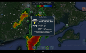
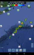
気象情報
- 気象降水レーダー (米国とハワイのみ)。エリア内の雨や雪を検出します。
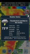
- ウェザーステーション。最寄りの観測所データをレポートします。現在の気温、湿度、気象条件、風など!ステーション観測データは世界中で利用できます。
- 天気予報。ウェザー ステーションは、激しい雷雨警報やハリケーン警報など、国立気象局によって発行されたアクティブな気象警報も報告します。気象警報情報は、米国、アラスカ、ハワイで利用できます。
- 地表面温度オーバーレイ。土地の現在の表面温度を表示します (米国のみ)。
このアプリケーションを使用する前に、次の使用条件/サービスおよびプライバシー ポリシーを読み、同意してください。
利用規約/サービス: http://www.marineways.com/appterms
プライバシー ポリシー: http://www.marineways.com/appprivacy
NOAA からの航海図の免責事項:
NOAA ENC Online は、ナビゲーションの認定を受けていません。ここに表示されている ENC のスクリーン キャプチャは、連邦規則集のタイトル 33 および 46 に基づく規制された商船の海図運送要件を満たしていません。
アプリをお楽しみください! Marine Ways は、http://www.marineways.com の Web でも入手できます。
Marine Ways - Nautical Charts- APK情報
APKバージョン: 1.41パッケージ: com.marineways.androidMarine Ways - Nautical Chartsの最新バージョン
他のバージョン


同じカテゴリのアプリ

その他のおすすめ...


